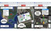
GeoView from Connected Technologies brings the power of Google Maps to the Connect ONE cloud-hosted security management platform. With GeoView, users see the current status for all locations and installations instantly in a wide-area satellite map. Users drill down into each location for real-time alarm, health and system monitoring and control — with GeoView showing the exact zone and location on alarm or alert. Users have secure access to a map of their building(s), providing information at a glance through designated icons that indicate live system status. The size of the map view only opens to the boundaries of site locations, keeping views relevant to customer’s locations. Users also get instant visual notification over the map for alarm activation — depicted with a flashing red icon, yellow for a troubled condition and green indicating good health status. All locations and status of systems installed are depicted on one screen. Users view and control equipment by clicking on icons of cameras, zones and sensors, doors and outputs, as well as manage the arming and disarming of intrusion systems. Users can also monitor activity and send commands to remotely lock or unlock doors or tap into cameras for a quick look at the surveillance areas. Overlay interior floor plans provide easy reference of equipment locations along with viewing and control, while the map of system and building particulars are easily modified if required.
Connected Technologies | www.connectedtechnologies.com


